Advocacy

An Update on Roland Avenue

UPDATE to the Update: 

Last week, BCDOT presented options for revision of Roland Avenue. Their “preferred option” is a road diet that takes Roland Avenue down to one lane in each direction. This would slow traffic while allowing for a wider parking lane, reducing parking intrusion into the bike lane. This design would solve  It also is by far the most cost-effective and quickest to implement solution.

While several other designs presented would maintain an all-ages bike lane, they would cost in excess of a million dollars, money that can and should be spent building infrastructure in the rest of our city where it is desperately needed.

Two designs were presented that would remove protected, all-ages lanes entirely. Removing protected infrastructure on streets where our city-adopted plans require it is a dangerous and likely illegal move that we cannot support.

You can see the presentation and the options here.

Please use the below tool to send comments in support of the preferred option, #1:


image005.jpg

In brief

On Thursday at 6:00pm at Roland Park Elementary School, Baltimore City Department of Transportation will be hosting yet another meeting on potential design revisions for Roland Avenue. It's likely that BCDOT will present at least one design option that is incompatible with adopted city guidance and removes parking protection and the all-ages classification of Roland Avenue. Please come out and show your support for a revised design that reduces a travel lane and keeps an all-ages, curbside protected bike lane on Roland Avenue.

Background: Roland Ave needs a road diet

Cars continue to speed on Roland Avenue, causing dangerous conditions for people walking, biking, or trying to enter and exit parked cars. This is not an issue with a bike lane, it's an issue with inconsiderate, speeding drivers. Luckily, it's solvable.

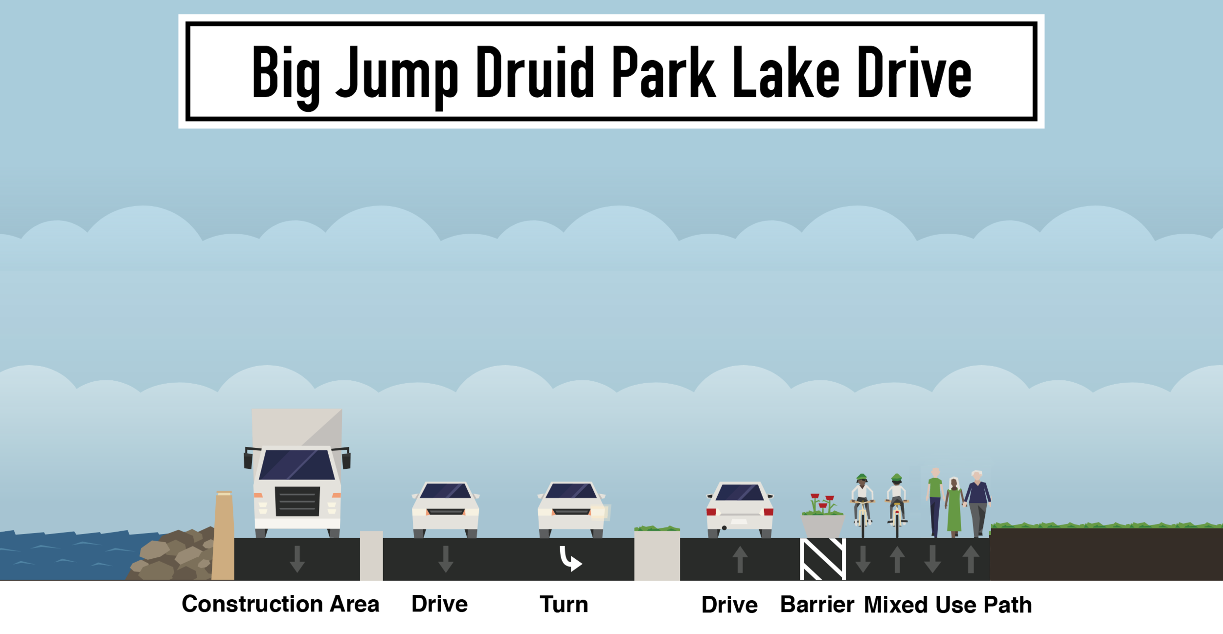
From day one, we have advocated for a road diet on Roland Avenue that would reduce the street to a single travel lane, a wider parking lane, and a wider curbside protected bike lane in each direction. This design is proven to slow vehicular travel speeds, by far the number one complaint about the current design on Roland Avenue. It is also the #1 design alternative listed in Roland Park Civic League's own commissioned Alta Planning report. 

Any new design for Roland Avenue must maintain an all-ages, physically separated bike facility. Baltimore City Department of Transportation's own guidance states this, as does our city-adopted Bike Master Plan and Separated Bike Network Addendum. 

Slide from the original BCDOT presentation on Roland Avenue, showing that traffic volumes and speeds on Roland Avenue require a physically separated bike facility.

Slide from the original BCDOT presentation on Roland Avenue, showing that traffic volumes and speeds on Roland Avenue require a physically separated bike facility.

Some say tear it out

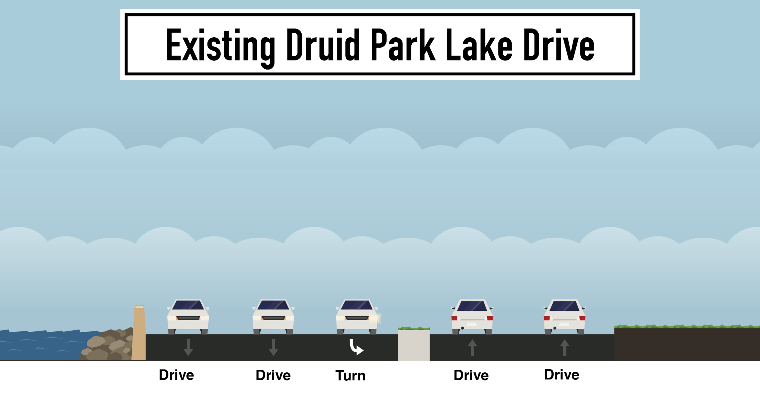
Some neighbors in Roland Park continue to advocate for removal of the curbside bike lane and restoration of curbside parking.

Restoration of curbside parking would create a remaining area that is visually massive, contributing further to speeding cars along Roland Avenue. The Roland Park Civic League commissioned Alta Planning Report agrees with our assessment: "The travel lane may not seem narrower...and therefore will not calm traffic to the same degree as modification #1."

Returning parking curbside would require installation of a new median-side bike lane separated only by flex posts, or striping of a standard buffered bike lane, against BCDOT guidance. Either design would remove the all-ages, parking-separated nature of the original facility, a step backward in safety for people who bike.

Tearing it out has a cost

While additional striping for a road diet that keeps the bike lane curbside is cheap, returning parking curbside would require milling and resurfacing of Roland Avenue to install a significantly different striping pattern. This would cost upwards of $500,000 of local dollars.

For comparison, the local dollar contribution for BCDOT to build the entire separated bike network plan for West Baltimore is $464,848.

11.5 miles of separated and supporting facilities in West Baltimore could be built for the cost of returning parking curbside on Roland Avenue.

11.5 miles of separated and supporting facilities in West Baltimore could be built for the cost of returning parking curbside on Roland Avenue.

Enough is enough

Baltimore City Department of Transportation has now spent years meeting with a vocal minority of Roland Park residents. The only reasonable and safe solution to their complaints happens to be the cheapest solution: striping a road diet and keeping a protected bike lane curbside. 

Any more time or dollars spent on this project = time or dollars that could be spent on increasing access to opportunity to residents most in need of it.

If Baltimore City Department of Transportation dares spend $500,000 on resurfacing Roland Avenue to make the street less safe for people biking instead of investing that money into expanding bike access into West Baltimore per the city's own adopted Separated Bike Lane Network Plan, they will be exacerbating inequity and doubling down on our city's well documented history of structurally racist infrastructure spending.

A Brief Update on Fire Access

A project before the planning commission tomorrow that does not comply with BCFD's interpretation of Appendix D of the International Fire Code.

A project before the planning commission tomorrow that does not comply with BCFD's interpretation of Appendix D of the International Fire Code.

The mayor's office has committed to resolving the ongoing discrepancies in Baltimore City Fire Department's interpretation of Appendix D of the International Fire Code. We believe that the likely resolution will be in the form of an emergency access commission that reviews and grants or rejects exceptions to the current interpretation of Appendix D. We have a number of concerns with this approach, including that it will inevitably lead to inconsistency as major developers will spend the time to lobby for exemptions while smaller development projects or city projects like street re-design likely will simply stick with the code as written--which will be bad for urban design and street safety.

As we continue to discuss a permanent resolution, inconsistency is rampant. The Fire Department demanded a re-design of Potomac Street, adjacent to two story rowhomes, but demanded no such re-design for Preston Gardens, adjacent to several hundred foot tall buildings, despite clear width on these streets being the same.

We have sent the below letter to the Baltimore City Planning Commission about several major development projects on the commission agenda tomorrow that fail to meet BCFD's current interpretation of Appendix D of the IFC.

We want to be clear that we support good urban development. We don't want the fire code to hold these projects up either. But we just don't understand how these projects can move forward while BCFD demands re-design of major bicycle infrastructure projects that would have created similar or even better fire access conditions than these developments.

Downtown Bike Network Update

The Downtown Bike Network, previously on construction hold due to Baltimore City Fire Department's unique interpretation of International Fire Code, has been re-designed with that interpretation in mind by Baltimore City Department of Transportation.

The new design switches from one-way pairs of infrastructure along Madison and Monument Streets to a fully-separated two-way bike lane along Centre and Monument Streets. This is a major improvement over the original design, providing a fully separated corridor along the length of the project. A buffered bike lane on Madison in Mount Vernon is maintained to provide traffic calming long requested by the Mount Vernon Belvedere Association.

In no place are existing condition street widths being reduced, and in many locations clear widths are being increased, so there should be no issue with Baltimore City Fire Department approval. If approved by Baltimore City Fire Department, the project construction will resume and hopefully be complete by end of Summer 2018.

We thank Baltimore City Department of Transportation for their effort in this re-design, which manages to both address unreasonable fire access demands while improving the separation of the facility.  


#FightForBikes 2.0

Skip the background, what can I do right now?

Fill the Room. Show up and Speak out at the following meetings:

  1. Covington Street Cycle Track | Wednesday, May 9 | 6:30-8:00pm

  2. Downtown Bike Network | Monday, May 14 | 6:30-8:00pm

  3. Downtown Bike Network | Tuesday, May 15 | 6:00-7:30pm

Background: Downtown Bike Network

Originally due to be installed in 2015-2016, the Downtown Bike Network included protected bike lanes on Centre Street, Madison Street, and Maryland Avenue, and standard bike lanes on Monument Street, Preston Street, and Biddle Street.

Maryland Avenue was installed, but the remainder of the network has been on a construction halt since Spring of last year due to complaints from the Baltimore City Fire Department, which is requesting 26 feet of clear street width on protected sections of the network. 

It is possible to re-design an east-west, fully-separated, all-ages facility within the Baltimore City Fire Department constraints, but it would likely remove parking.

The city has extended the construction halt as long as they can, and construction must continue this Spring or we risk losing the contract and spending significant additional resources.

As a result, we support the concept of a re-design to address Baltimore City Fire Department's unreasonable constraints, but believe whatever is installed must maintain a separated, all-ages design from project limit to project limit. 

Background: Maryland Avenue

Maryland Avenue looks finished. But technically, the job hasn't been closed out. There is still some paint to be laid. As a result, it is still in limbo. Baltimore City Fire Department claims it fails to meet their fire clearance requirements. On large portions of Maryland Avenue, protection would need to be removed to meet those requirements. 

We oppose making changes to Maryland Avenue because it is a NACTO compliant, nationally recognized bike lane and because other projects that were installed during the same time period are not being threatened in a similar way. 

Background: Roland Avenue

Bikemore has long advocated for a road diet on Roland Avenue, reducing the street to one travel lane in each direction. This would allow for a wide parking lane and a wide, all-ages bike lane that is protected from moving traffic by parked cars. Data shows a single lane of travel is enough to accommodate the volume of traffic Roland Avenue sees every day, and that this is the best opportunity to reduce the frequency of which cars dangerously speed along the corridor. 

Baltimore City Department of Transportation opted not to pursue a road diet in their original design of Roland Avenue. As a result, the bike lane is too narrow, parking is too narrow, and the remaining two travel lanes still encourage dangerous speeding. Neighbors rightly complain about these conditions.

For the past year, Bikemore has worked alongside Roland Park Civic League and stakeholders along the corridor to advocate for changes to make Roland Avenue safer for all road users. It's clear that the only design that could address speeding cars, narrow lanes, and maintain an all-ages bike lane is a road diet that keeps the bike lane against the curb.

This option was recently presented at meeting in Roland Park, but a vocal contingent of residents is demanding that instead of a road diet, Roland Avenue should simply be returned to the original condition of two travel lanes with parking against the curb. This would solve none of the safety complaints, because it would keep two wide travel lanes for speeding cars and remove protection for people on bikes, forcing them to ride next to or in traffic with those speeding cars. Kids would no longer have a safe way to bike to school. It would be a choice to value the convenience of parking 8 feet closer to the curb over the lives of neighbors.

We support a road diet that slows down cars, widens parking lanes, and keeps a protected curbside bike lane where people of all ages can safely ride a bike.

Background: Covington Street

Covington Street is another project that was beginning design when this drama began. It is still proceeding. The goal is to make a parallel all-ages biking connection to Key Highway, connecting from the soon-to-be expanded Jones Falls Trail at the Inner Harbor to Riverside Park. 

The current design is only protected adjacent to the American Visionary Art Museum. It changes to sharrows (painted bike symbols on the road) to the south. Sharrows are not bike infrastructure. They are for wayfinding. This fails the goal of an all-ages connection.

We support the extension of the protected facility or the installation of speed humps and other bicycle boulevard treatments to ensure the entire facility, especially the part in front of Digital Harbor High School, is all-ages.

Tell me about the Fire Access Issue.

When a vocal minority of neighbors began to look for ways to fight against the installation of Potomac Street, they engaged the Baltimore City Fire Department on a piece of city-adopted International Fire Code that requires 20 feet of clearance on Fire Apparatus Access Roads. 

This piece of adopted IFC had not previously been applied in street reconstruction. Other portions of city-adopted IFC require 26 feet of clearance on Aerial Fire Apparatus Access Roads (streets with buildings over 30 feet) and 26 feet of clearance on streets with fire hydrants. 

We've been assured that these rules are to be enforced on all street reconfiguration, not just street reconfigurations with bike lanes. However, we have yet to identify a piece of infrastructure without bike lanes that has been halted or threatened, and many non-compliant projects have proceeded including the Preston Gardens reconstruction that occurred over the past year which features just 12 feet of clearance adjacent to a several hundred foot tall building.

We demand that any resolution to the fire access issue be clear and fairly applied to all street reconstruction and retrofit and all new building construction and retrofit in Baltimore City per the requirements of the International Fire Code. Any resolution must encourage urban street design based on national best practices that reduce injury and death of vulnerable road users.

Big Jump: Druid Park Lake Drive and 28th Street

Proposed Changes to Druid Park Lake Drive

In January of last year, Baltimore was one of 10 cities selected for the PeopleForBikes Big Jump Project, a grant aimed at bolstering ridership in an already successful community and expanding that ridership into adjacent communities. Reflecting that grant constraint, Baltimore City's application focused on improving connectivity between an area of high opportunity, Remington, and areas in need of opportunity, including Penn North and Reservoir Hill. 

In late May, Baltimore City Department of Transportation plans to install the first component of the the Big Jump Project.

The ongoing DPW Druid Lake Reservoir construction and the traffic changes necessary to stage equipment for that project will result in lane closures on Druid Park Lake Drive. Taking advantage of these already required road closures, we're able to construct a walking and biking connection across Druid Park Lake Drive and the 28th Street bridge, connecting Remington directly to Reservoir Hill and Penn North. 

The current crossing is a narrow sidewalk alongside highway speed travel lanes that leads to a non-ADA accessible pedestrian bridge and an overgrown path alongside a highway onramp. Photos of existing conditions are below.

The new connection would be a wide shared-use path separated by water-filled barriers and planters. It will extend from Atkinson Street in Remington to Madison Avenue on the border of Reservoir Hill and Penn North. Additionally, the path will extend north on Sisson Street in Remington to connect to the existing Jones Falls Trail at Wyman Park Drive and extend west along an existing path and sidewalk to connect to the basketball courts on Druid Hill Avenue.

The proposed barrier-protected bike and pedestrian path route is outlined in teal above.

The proposed barrier-protected bike and pedestrian path route is outlined in teal above.

The installation of this walking and biking path in late May will reduce Druid Park Lake Drive to one lane eastbound. Reservoir related construction will reduce Druid Park Lake Drive to one lane westbound. Not only will this project provide a safe walking and biking connection between neighborhoods across a highway, it will halve the crossing distance for pedestrians looking to access Druid Hill Park from neighborhoods to the south. 

Baltimore City Department of Transportation is also engaging in a large-scale corridor study of Auchentoroly Terrace and Druid Park Lake Drive. The goal is to incorporate the successes of this Big Jump Project idea into permanent road reconfiguration or removal to better reconnect Druid Hill Park to the neighborhoods surrounding it, while creating permanent safer walking and biking connections.

This idea has become a potential reality due to persistent advocacy and leadership from Bikemore and Councilman Leon Pinkett, as well as a commitment to The Big Jump Project from BCDOT Director Michelle Pourciau, dedicated and creative staff like Graham Young, and the Mayor's Bicycle Advisory Commission.

Community meetings outlining this project are coming up, and we encourage neighbors to come out to learn more and support this project. Details are below.

Screen Shot 2018-04-17 at 3.09.46 PM.png