
Baltimore City Department of Transportation is planning a "Traffic Calming and Streetscaping" process to improve the Belair Road Corridor. Urban Land Institute was hired for a visioning process to identify opportunities for destination retail establishments along the corridor. The study concluded that the corridor '“suffered from too much high speed traffic, and that traffic calming and a new pedestrian, transit, and bicycle friendly streetscape were necessary if the corridor wanted to become a destination for retail establishments like restaurants, shops, and other places worth visiting.”
Unfortunately, the proposals that DOT has designed for Belair Road will do nothing to address the root issues identified by Urban Land Institute.
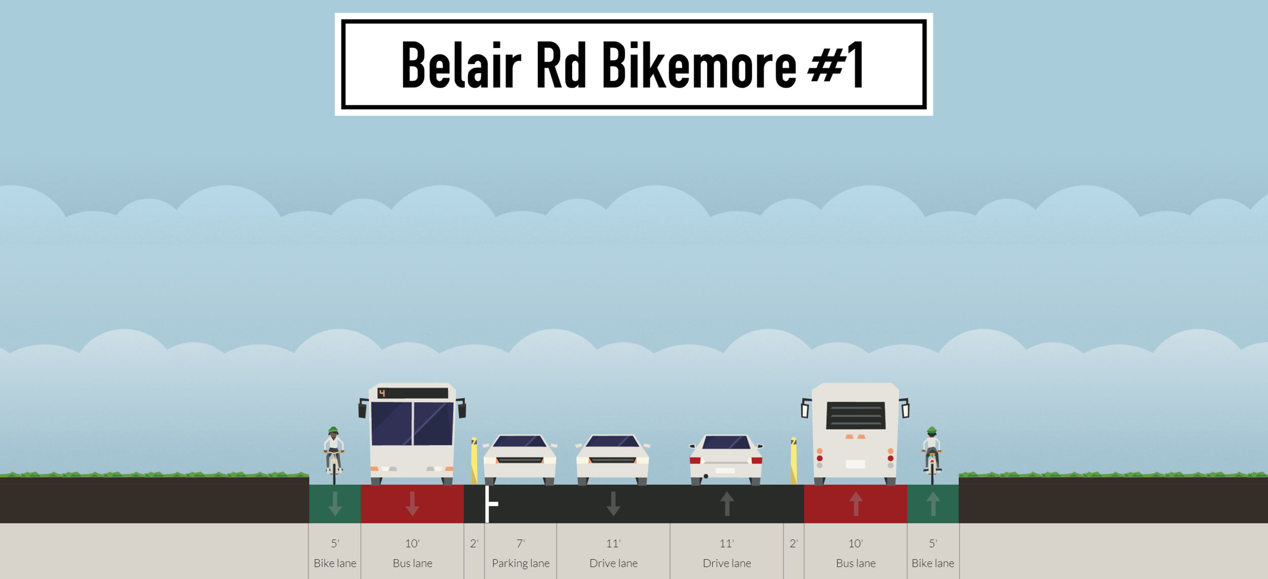
The first proposal maintains interstate highway width traffic lanes. The only pedestrian friendly amenity added is improved crosswalks with bumpouts to reduce pedestrian crossing distance. "Sharrows" are provided for cyclists, despite DOT's own recommendations that they are useless safety treatments on arterial roads.
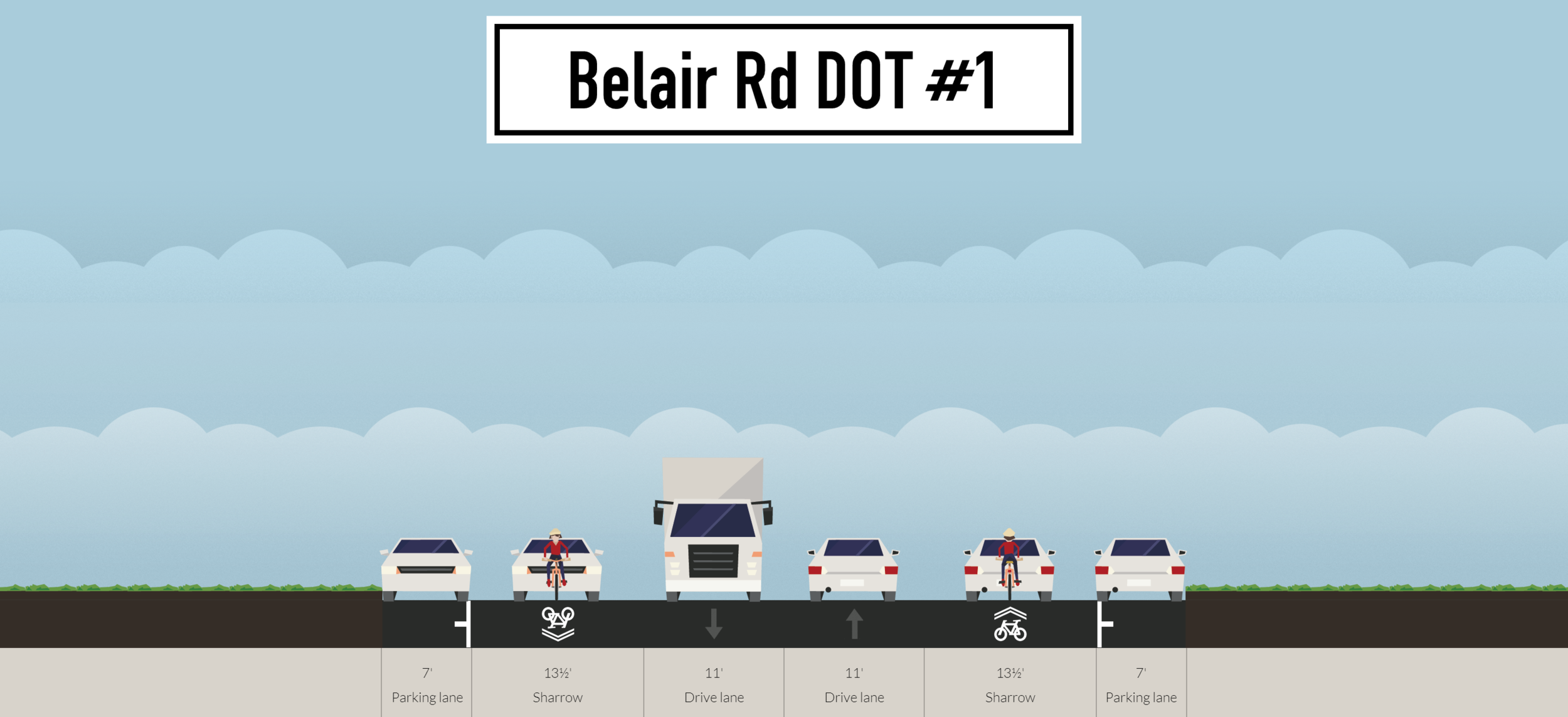
belair-rd-01
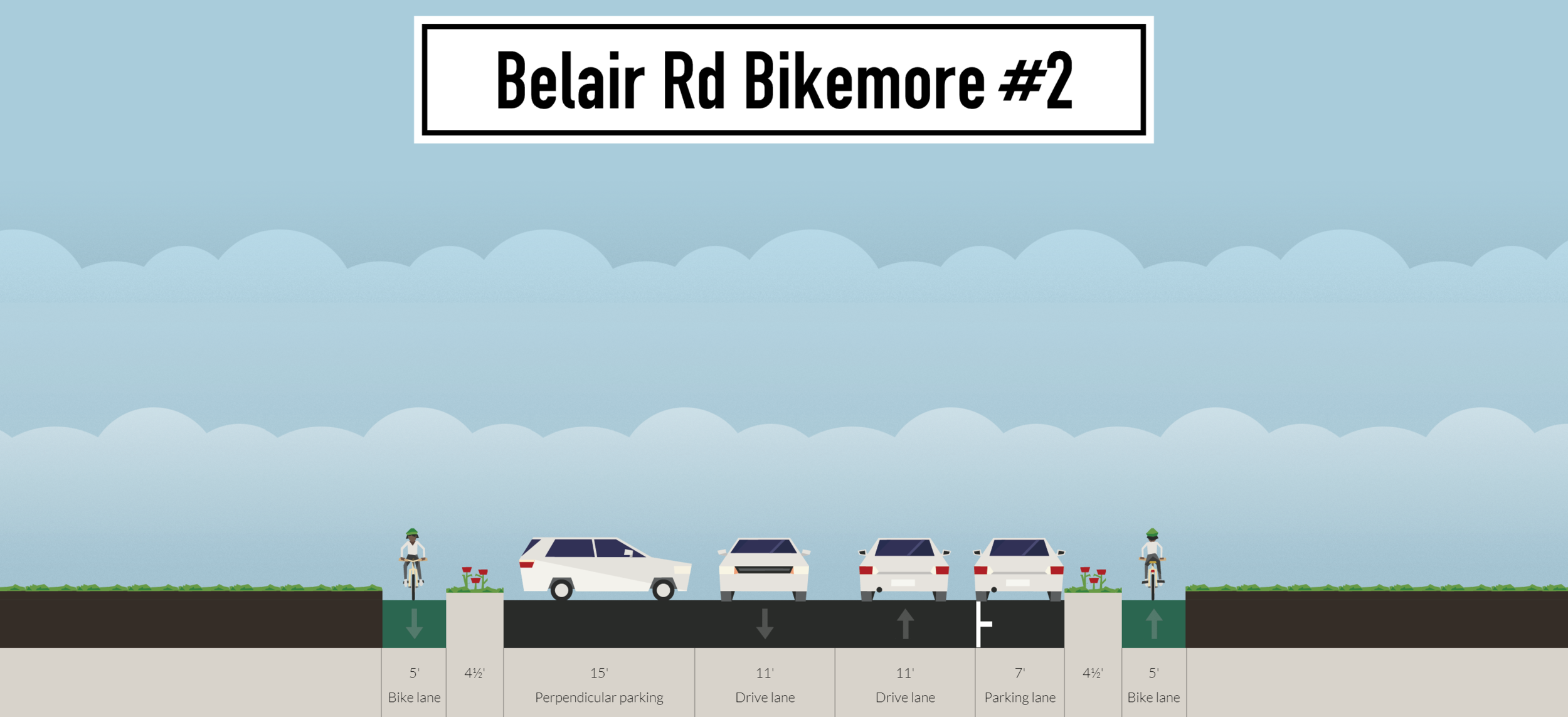
The second proposal reduces traffic lane width to 11 feet and adds a median in the middle of the street. While this will slow vehicular traffic somewhat, the lanes are still 2-3 feet wider than most traffic lanes striped by cities looking to calm traffic. DOT contends this width is necessary due to buses and trucks using the street. Again, sharrows are provided for cyclists, against DOT's own recommendations to never use sharrows as a treatment on arterial roads.
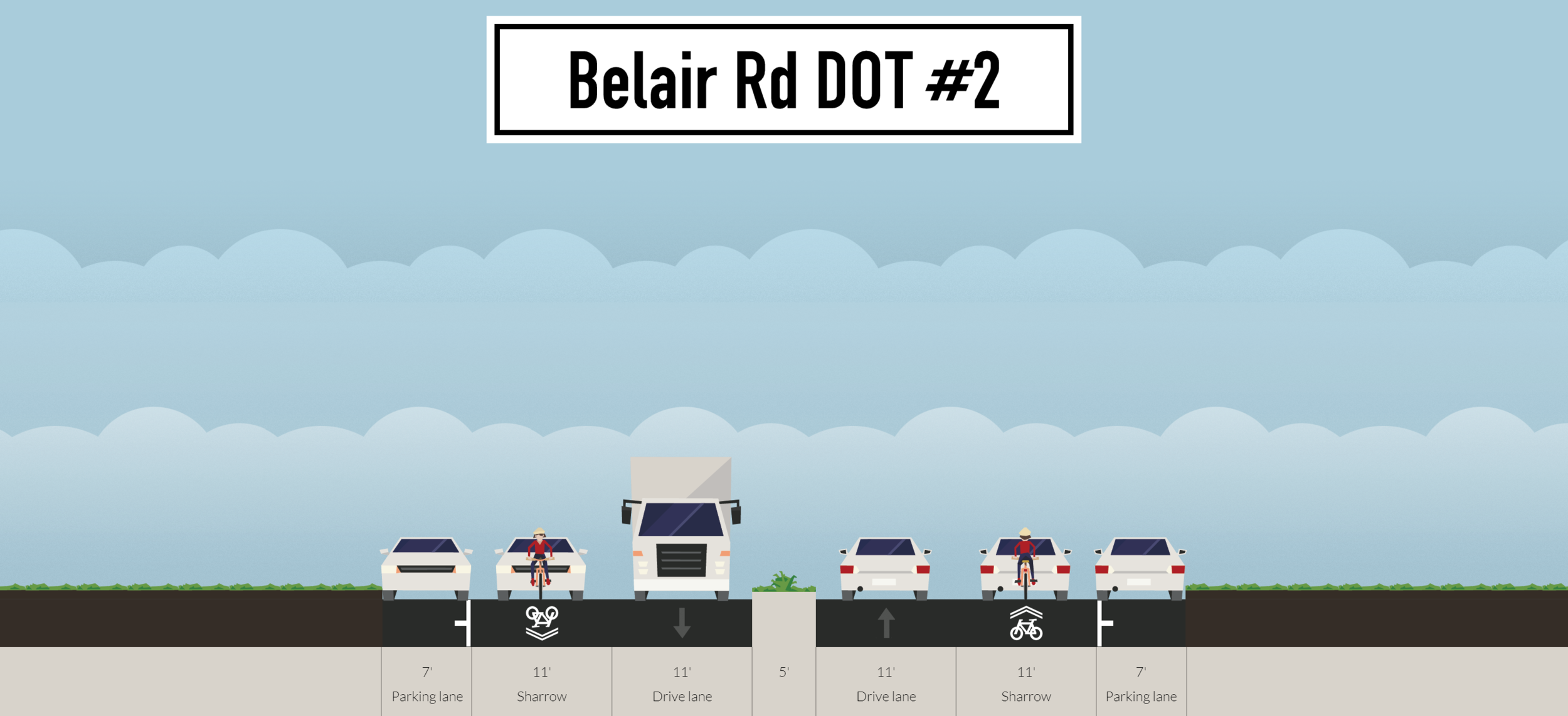
belair-rd-02
We think there is a better approach. If the goal is to make Belair Rd a corridor where people want to stop, shop, eat, and play, traffic speed needs to be reduced. It needs to be safe to walk, bike, park, and take the bus.
DOT contends the only way to provide proper bike infrastructure is to remove parking. We don't agree. Businesses need parking to survive. But they also need safe pedestrian and bicycle access to thrive.
Removing one travel lane each direction on Belair Road would serve the same purpose as a median. It would reduce crossing distance, and it would calm traffic. More importantly, it would free up road space to be used for things that would make the corridor an attractive place to stop and visit, rather than to drive through as quickly as possible.
Yes, eliminating a lane of traffic in each direction on Belair Road would mean reducing road capacity during rush hour. We believe that access and safety for people walking and riding bicycles along the Belair Road corridor are more important for the development of human-friendly urban communities than traffic speed and capacity during a short portion of each weekday. People should not have to take their lives in their hands to walk or ride a bicycle along or across Belair Road simply for the convenience of people driving during rush hour -- many of whom do not live in the city. For people driving into Baltimore from the northeast, there are plenty of other roads to use -- Route 40, I-95, Harford Road, Perring Parkway, Loch Raven Boulevard, etc. If one of our preferred alignments were implemented, there might be some congestion and confusion at first, but people will quickly learn to drive on other roads if their destinations are not along Belair Road.
belair-rd-03
An option like this one would remove parallel parking on one side of the street, but add dedicated bus lanes and dedicated bike lanes. Approaching retail clusters, the bike/bus lane could become shared, allowing the addition of reverse angle parking to one side of the street. This would increase available parking, provide better transit service to the corridor, and leave room for dedicated bicycle infrastructure.
belair-rd-04
Or, the dedicated transit lanes could be tabled, as seen above, allowing for dedicated bicycle infrastructure, parallel parking on one side of the street, and reverse angle parking on the other side of the street. This would slow traffic and decrease road crossing distance for pedestrians, while adding significantly more parking to the corridor, as well as dedicated bicycle infrastructure protected by raised medians.
belair-rd-04'
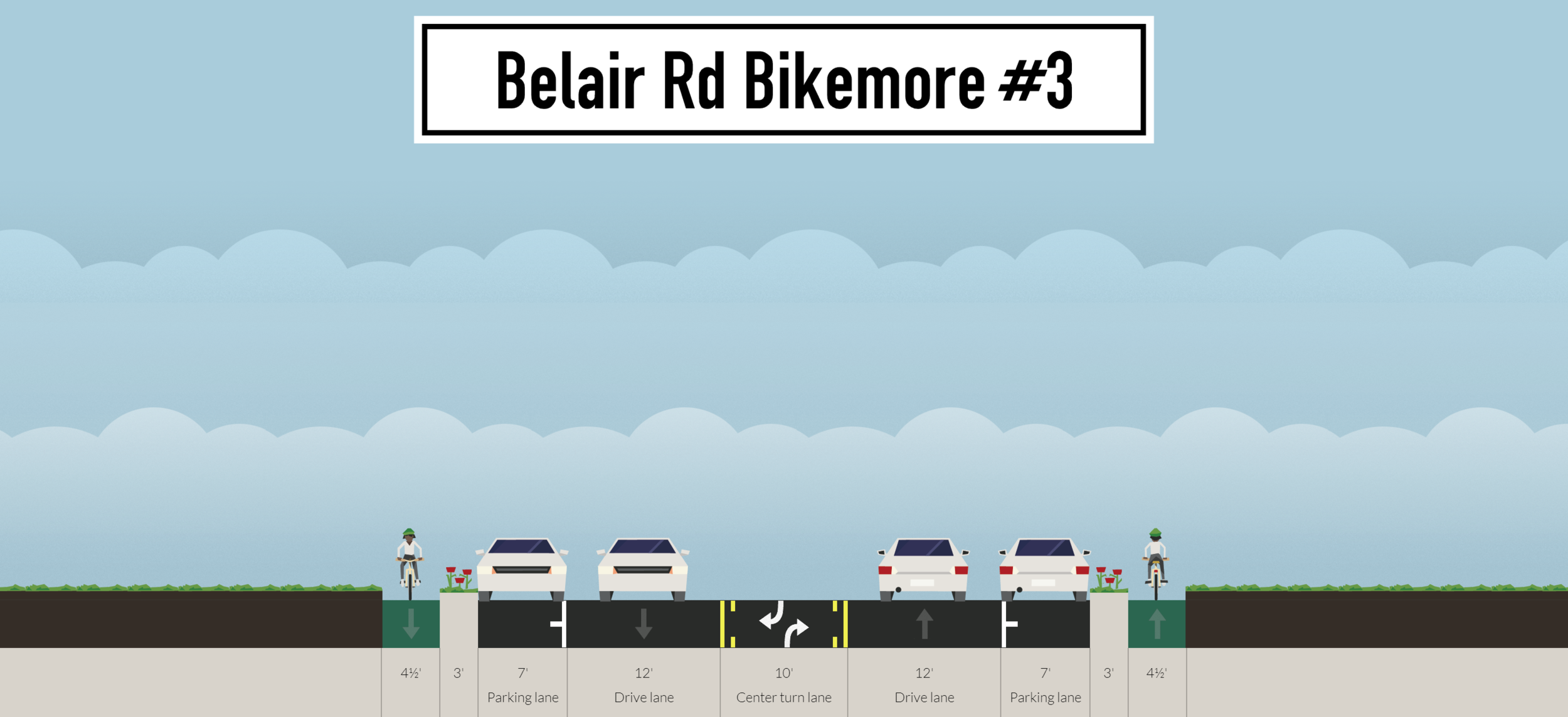
Or, the parallel parking could remain on both sides of the road, and a shared turn lane could be installed down the middle. In this instance, there is still room for dedicated bike infrastructure, protected by medians. Notice we've even left a ridiculously wide 12 foot lane each way in this rendering.
Our message is this: if DOT is serious about creating a Belair Road corridor that will attract retail establishments and their customers, they need to think bigger than 4 lanes of freshly-paved highway-width roadway with pretty brick crosswalks at the intersections.