

Baltimore City Department of Transportation’s latest one-off planning study focuses on Boston Street, attempting to consolidate planning over the past decade and make recommendations for “multimodal transportation” improvements. It is disastrous.
The report highlights that the majority of travel through the corridor is single occupancy vehicles, and the biggest barriers to shifting modes away from single occupancy vehicles are a lack of high frequency, reliable transit, and a lack of low-stress bicycle facilities in the corridor.
Given these barriers, it would make sense for the Boston Street Multimodal Corridor Study to focus on biking, walking, and transit improvements to Boston Street. This would be consistent with city planning documents going back almost a decade.
Planning History
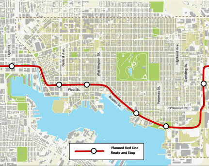
The most significant planning along the Boston Street corridor was for the Baltimore Red Line, which would have provided a significant public transit improvement connecting Baltimore West to East, and would have run along the Boston Street Corridor. The plan for the Red Line contained buffered bike lanes on Boston Street that transitioned to “bike priority” lane markings at station areas where additional street width was needed.
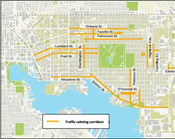
The 2012 Southeast Complete Streets Master Plan called for installation of bicycle facilities and sidewalk widening on Boston Street to support “heavy pedestrian traffic for active commercial districts.” It called for treating Boston Street as a “traffic calming corridor” and installation of urban greening to create a greenway, all to complement the coming Red Line.
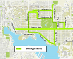
The 2015 Bike Master Plan follows the lead of these prior documents, retaining Boston Street as a “Main Route” for biking, which calls for “bike lanes, buffered bike lanes, cycle tracks.”

2015 Bike Master Plan planned bike facilities on Boston Street
The 2015 Southeast Transportation Vision produced before cancellation of the Red Line proposes a bike lane on Boston Street. The 2016 update, produced after the Red Line cancellation, maintains this recommendation.

Southeast Strategic Transportation Vision planned bike facilities on Boston Street
In sum, over a decade of planning involving countless residents, city, and state elected officials, appointed bodies, and BCDOT and MTA/MDOT staff advanced multiple planning documents focused on improving biking, walking, and public transit to improve quality of life for Canton residents.
The Abrupt Change
In 2017, something changes. At the same time the Boston Street Multimodal Corridor Study begins, the Protected Bike Lane Network addendum begins. Despite Boston Street being identified as a “high stress” street “requiring a bike facility to comfortably cross” in the Protected Bike Lane Network Addendum, Bikemore is told that the “scope of the plan” prevents Boston Street from being included for “political reasons.”
We assumed that this "political" limitation meant that we should expect a Boston Street Multimodal Corridor Study to eschew over a decade of true multimodal planning for moving people on Boston Street, and instead focusing on moving cars.
We were right.
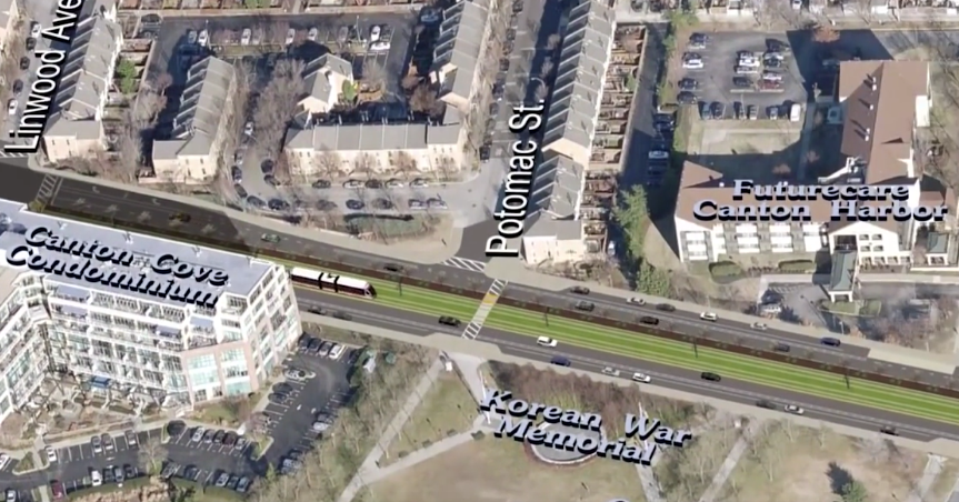
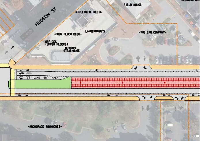
The first recommendation in the study is to build a major new road connecting Toone Street to Boston Street, while widening Boston Street between Haven and Conkling Streets. This widening does not include all-ages, low-stress bike infrastructure—it is solely focused on speeding up cars. The cost of this widening is listed at $2,000,000, and is part of a larger $50,000,000 idea to continue widening Boston Street even further east.
The next recommendations focus on moving vehicles through the neighborhood at the expense of safety and quality of life. The most egregious:
- Peak hour parking restrictions throughout the corridor are recommended to be expanded, with heightened parking enforcement, to ensure maximum road space allocation to promote speeding cars.
- Peak hour parking restrictions are recommended for Boston @ Fleet Street, creating a second through lane.
- Crosswalk removal is proposed at Boston and Aliceanna Street to speed signal timing for cars trying to turn right onto Boston from two turn lanes on Aliceanna at the expense of safe crossing for pedestrians.
- Lane expansion is also proposed at Boston and Clinton Streets to build 2 turn lanes. Dual turn lanes are commonly proposed in Baltimore but anti-pedestrian and discouraged by our own adopted planning guides.
For walking improvements, the plan audaciously calls for “continuous sidewalks.” It recommends upgrade of sidewalks to include ADA curb cuts, something already required by law. It suggests re-striping faded crosswalks, and it recommends installing pedestrian signals.
For biking improvements, the plan calls for bicycle boulevards on Foster and Hudson Street. These parallel routes have been suggested for almost a decade, and were originally planned to complement Boston Street, not be a substitute for it. The plan suggests the narrow promenade, intended for recreational bicycling during a one year pilot period, could somehow serve as a commuting alternative.
For transit, the plan suggests rerouting one commuter bus, assigning some carpool parking in parking lots, encouraging more private shuttles, and “exploring” expanded/improved water taxi service.
Our View
The Boston Street Multimodal Corridor Study is a plan to spend millions of dollars to dramatically boost the capacity on Boston Street for car commuters at the expense of safe walking, biking and public transit access for residents.
It fails to take into consideration decades of planning for a more walkable, bikeable, livable Canton. It fails to follow planning-commission adopted city planning documents. It fails to meet standards in city’s adopted street design guides.
It is a bad plan.
Share your Comments
Comments on the Draft Final Report can be submitted at the following link: https://www.surveymonkey.com/r/Boston30
We encourage you to demand a true multi-modal Boston Street, that prioritizes walking, biking, and public transportation access in Canton over county commuters passing through the neighborhood on their way downtown.