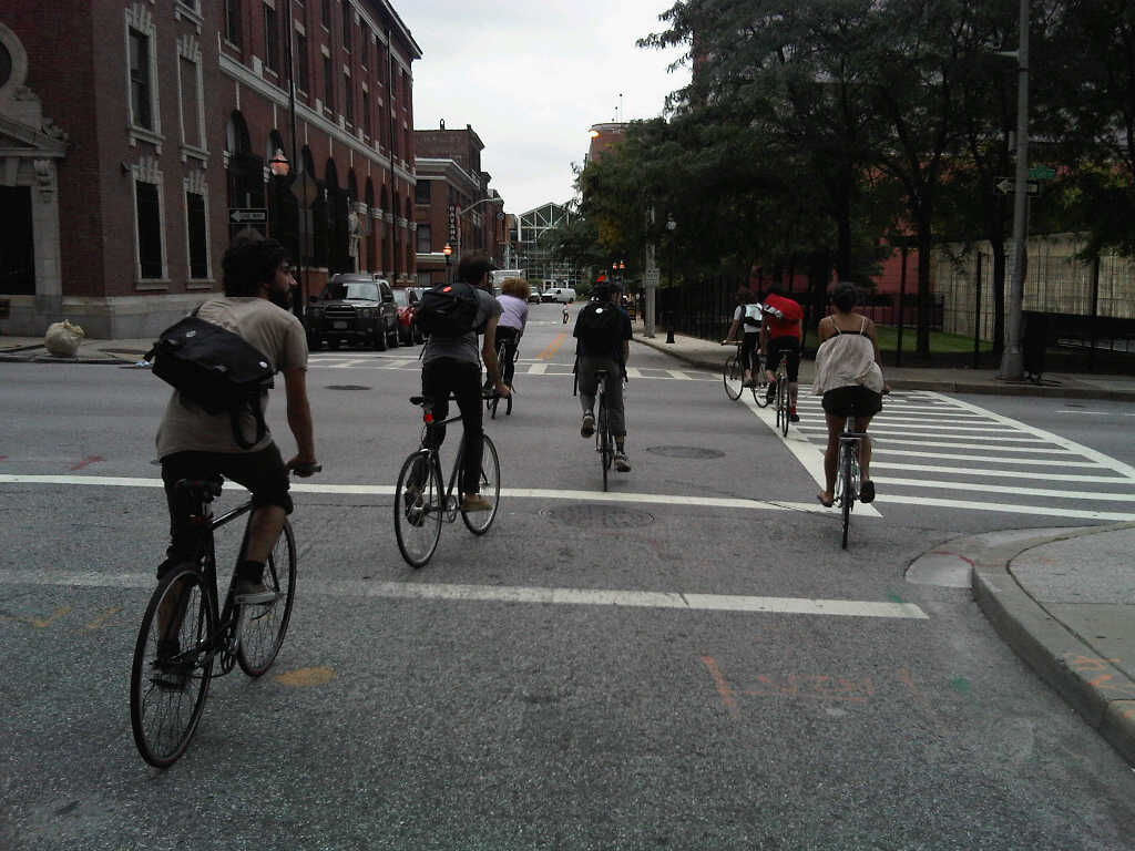

The Baltimore City Department of Transportation (BCDOT) has committed $3 million in 2014 to build a series of bicycle infrastructure projects collectively known as the Downtown Bicycle Network. We offer the following recommendations, based on BCDOT’s presentation of February 4, in the spirit of constructive input and ongoing collaboration. A letter nearly identical to this post was sent via email and snail mail to BCDOT leaders on March 27, 2014.
In this post, “Maryland Avenue Cycletrack” refers to the entire protected bicycle lane along Maryland Avenue, Cathedral Street, Liberty Street, and Hopkins Place between 29th Street and Pratt Street, while “Downtown Bicycle Network” refers to the Maryland Avenue Cycletrack plus proposed standard bicycle lanes on Centre, Madison, Monument, Biddle, Preston, and Dolphin Streets.

The proposed Downtown Bicycle Network to be constructed in 2014, plus the Mount Royal Avenue Cycletrack and the Guilford Avenue bicycle lane.
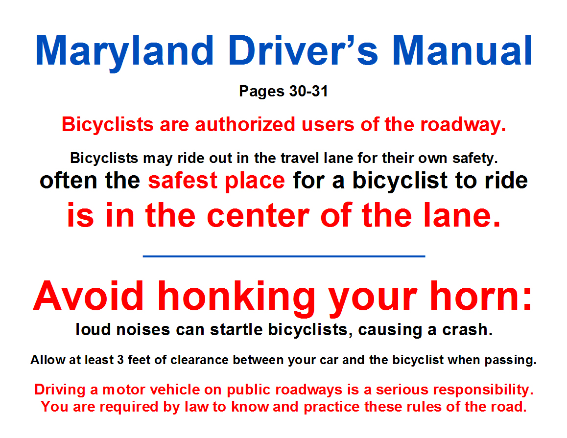
Assuming that, in the short term, pedestrian crossing signals are to be used as bicycle crossing signals along the Maryland Avenue Cycletrack corridor instead of bicycle-specific signals, BCDOT should install pedestrian crossing signals at every signalized intersection along the corridor that is currently missing any pedestrian crossing signals. If it were built today, northbound bicycle traffic at several intersections along the corridor would not have a clear signal of when to proceed without a pedestrian crossing signal.

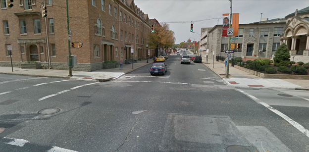
Signalized intersection without pedestrian crossing signal at Maryland Avenue at 27th Street.
Add a 5-second leading interval for all bicycle/pedestrian signals and ban all turns on red in every direction at each signalized intersection that the Downtown Bicycle Network touches:
Maryland Avenue / Cathedral Street / Liberty Street / Hopkins Place at Pratt, Lombard, Baltimore, Fayette, Lexington, Saratoga, Mulberry, Franklin, Centre, Monument, Mount Vernon Place, Madison Street, Read, Eager, Chase, Biddle, Preston, Mount Royal, Oliver, Lanvale, Lafayette, North Avenue, 20th, 23rd, 24th, 25th, 27th, 28th, and 29th
Dolphin Street at Fremont, Myrtle, Pennsylvania, Druid Hill Ave, McCulloh, Madison Avenue, Eutaw, and Howard
Preston Street at Cathedral, Maryland, Charles, Saint Paul, Calvert, Guilford, Greenmount, Ensor, Aisquith, Harford, Central, Caroline, Broadway, Wolfe, and Washington
Biddle Street at Cathedral, Maryland, Charles, Saint Paul, Calvert, Guilford, Greenmount, Ensor, Aisquith, Harford, Central, Caroline, Broadway, Wolfe, and Washington
Madison Street at Paca, Eutaw, Howard, Park, Cathedral, Charles, Saint Paul, Calvert, Guilford, Fallsway, Greenmount, Ensor, Aisquith, Harford, Central, Caroline, Broadway, Wolfe, and Washington
Centre Street at Paca, Eutaw, Howard, Park, Cathedral, Charles, Saint Paul, Calvert, Guilford, and Fallsway
Monument Street at Greenmount, Ensor, Aisquith, Harford, Central, Caroline, Broadway, Wolfe, and Washington
Guilford Avenue at Pratt, Lombard, Baltimore, Fayette, Lexington, Saratoga, Mulberry, Franklin, Centre, Monument, Mount Vernon Place, Madison Street, Read, Eager, Chase, Biddle, Preston, and Mount Royal
This means that people on foot and on bicycles get a 5-second head start at every intersection, thus increasing their visibility and calming traffic by reducing potentially aggressive maneuvers from people in motor vehicles stopped at red lights. For example, as shown in the image below, a left turn on red is presently allowed from westbound Preston Street onto southbound Maryland Avenue; people in cars trying to make a left turn on red will be looking to their right for southbound car traffic here, which means they are less likely to see people on bicycles traveling northbound on the Maryland Avenue Cycletrack. Banning all turns on red would simply reduce the amount of things that people on foot and on bicycles would need to worry about.
Facing west on Preston Street at Maryland Avenue.

An existing leading pedestrian interval at Pratt and Light Streets.
Extend the Maryland Avenue Cycletrack from Hopkins Place across Pratt Street and along the east side of Sharp Street under the Convention Center, and create a high-quality connection across Conway Street to Sharp Street.
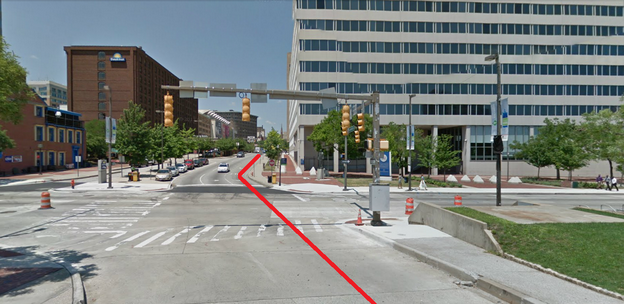
This view, looking north from Sharp Street across Pratt Street to Hopkins Place, shows in red the route that an extended Cycletrack should take.
Install wayfinding signage at major bicycle intersections:
Maryland Avenue / Cathedral Street / Liberty Street / Hopkins Place at 27th Street, 24th Street, Jones Falls Trail, Oliver, Biddle, Preston, Madison Street, Centre, Lombard, and Pratt
Dolphin Street at Pennsylvania, Druid Hill Ave, McCulloh, Madison Avenue, and Eutaw
Preston Street at Maryland, Guilford, Central, Caroline, Broadway, Wolfe, and Washington
Biddle Street at Maryland, Guilford, Central, Caroline, Broadway, Wolfe, and Washington
Madison Street at Eutaw, Park, Cathedral, Guilford, Fallsway, Central, Caroline, Broadway, Wolfe, and Washington
Centre Street at Eutaw, Park, Cathedral, Guilford, and Fallsway
Monument Street at Central, Caroline, Broadway, Wolfe, and Washington
Guilford Avenue / South Street at Pratt, Lombard, Centre, Madison Street, Chase, Biddle, Preston, and Mount Royal

Existing bicycle wayfinding signage on Guilford Avenue (photo courtesy of BCDOT).
Increase the door zone buffer to three (3) feet along the entire Maryland Avenue Cycletrack corridor. Three feet is the NACTO Design Guide standard for door zone buffer width, and the Cycletrack plans currently only call for two feet. The door zone buffer delineates the space where people should not ride because of opening car doors.

A 3-foot buffer on the 15th Street Cycletrack in Washington, D.C., cited by BCDOT as a model for the Maryland Avenue Cycletrack.
Install a reflective bollard at the north side of each block along the Maryland Avenue Cycletrack corridor so that southbound automotive traffic cannot enter the bicycle lane.

Cycletrack in Vancouver with bollard. Photo courtesy of velotraffic.com.
Install traffic separators on the door zone buffer along the full Maryland Avenue Cycletrack corridor to increase the awareness and feeling of separation and to simulate curb for parallel parking.

Traffic separators on a bicycle lane in Barcelona. Photo courtesy of pedalforward.blogspot.com.