Bike Lanes

Recommended Improvement to Bike Master Plan

The proposed bicycle master plan update includes many ambitious and excellent proposals for improving safety and comfort for bicyclists in Baltimore, whether they ride for recreation or transportation. The proposed bicycle facility network, once fully constructed, would allow many thousands of Baltimore residents and visitors to be able to use bicycle-specific infrastructure to access their jobs, schools, grocery stores, favorite restaurants, and social activities by bicycle. The health, quality of life, and local economic benefits of a high quality bicycle transportation network are well documented, and the City should be commended for its plans to implement these measures.

However, recent events in our City underscore the fact that it is not simply the presence of a bicycle facility, but also the type of bicycle facility that really increase the safety and comfort of bicyclists. 

The Master Plan Update includes the possibility of standard bicycle lanes on "main routes," which are often identified to be located on arterial roadways, and shared lane markings, or sharrows for "minor routes." There may be some streets where these treatments are appropriate, but facility selection must be strategic and sensitive to the operating conditions of the street, in order to maximize the safety and comfort of all users.    

Bikemore's proposal is that facilities with some physical separation be the default preferred facility for streets with 85th percentile speeds above 25 miles per hour. This is the suggested threshold because it is an approximation of the speed beyond which crashes between automobiles and bicyclists or pedestrians become dramatically more likely to result in death or grievous injury. We propose using measured 85th percentile speeds as opposed to the speed on the speed limit sign because of the frequency with which drivers exceed the speed limit. 

Furthermore, sharrows are only an appropriate choice for local streets, and in conjunction with traffic calming and "bicycle boulevard" measures that keep 85th percentile speeds below 25 mph, or, ideally, closer to 20 mph. It may also be appropriate to use sharrows to connect short gaps between higher quality facilities. This position is consistent with NACTO Bikeway Design Guidelines and emerging research about the safety and functionality of different bicycle facility types. 

These recommendations will result in the selection of safer, more comfortable facilities, while also allowing for creative solutions in locations where space may be too constrained for a separated bicycle facility. 

For example: if the 85th percentile speed on a street is above 25 mph even though the signed speed is not, and a separated bicycle facility cannot be accommodated, we would find it an acceptable solution to install the standard lane or a paint-buffered lane in conjunction with bicycle friendly traffic calming measures. In severely space constrained locations, standard painted bike lanes may be acceptable in the absence of traffic calming measures for small lengths of narrower cross section on a street, if other factors such as adjacent parking, driveway conflicts, and door zones are taken into account. Where these compromises must be made, we recommend that Bikemore or other credible bicycle advocacy entities be consulted to help collaboratively develop the safest and most comfortable bicycle facility that is feasible in the space available.  

Join Us for the Bike Master Plan Final Review

The Baltimore City Department of Transportation is updating the bicycle master plan, and will be holding a final public review of the document before adoption.

The Open House will take place at the Enoch Pratt Free Library Central Branch on Wednesday, January 28th from 5:30 to 7:00pm in the Auditorium. 

Please let Bikemore know if you're coming via our Facebook Event.  Full details are below: 


Beware on the Guilford Bike Boulevard

You may remember last April, there were a number of assaults on cyclists around the Copycat Building on Guilford Ave. This author was among the riders who was threatened but escaped physical injury. Mark Brown, former blogger at Car Free Baltimore, wasn't so lucky and incurred physical trauma.

According to this YouTube video and its accompanying Facebook post, these assaults are back. Here's the report from the victim:

[Video above] recorded on 4/12/14. Attacked by a group of teenagers on the bike route on the 1600-1700 block of Guilford Ave. You can hear when they threw a bottle at me from behind and then see when I try to grab my lock as a last resort as they started to attack, but dropped it. Grabbed it before they did. Only damage was to my thumb when they stomped it. Took punches, but they must have hit my helmet, because I don't have any marks. Camera cuts out at the end around this time. On the ground I started yelling "help help help". Residents started coming out and a distant siren scared them off. Called 911 after and met with an officer a few minutes later.

Please exercise extreme caution in this area. If you experience or witness an assault, report it to police and send them a video (if possible) to see if any faces can be made out. Feel free to contact BIkemore and we will initiate contact with our main people at the BCPD.

Be safe out there.

Bikemore’s Recommendations for the Downtown Bicycle Network

The Baltimore City Department of Transportation (BCDOT) has committed $3 million in 2014 to build a series of bicycle infrastructure projects collectively known as the Downtown Bicycle Network. We offer the following recommendations, based on BCDOT’s presentation of February 4, in the spirit of constructive input and ongoing collaboration. A letter nearly identical to this post was sent via email and snail mail to BCDOT leaders on March 27, 2014.

In this post, “Maryland Avenue Cycletrack” refers to the entire protected bicycle lane along Maryland Avenue, Cathedral Street, Liberty Street, and Hopkins Place between 29th Street and Pratt Street, while “Downtown Bicycle Network” refers to the Maryland Avenue Cycletrack plus proposed standard bicycle lanes on Centre, Madison, Monument, Biddle, Preston, and Dolphin Streets.

The proposed Downtown Bicycle Network to be constructed in 2014, plus the Mount Royal Avenue Cycletrack and the Guilford Avenue bicycle lane.

The proposed Downtown Bicycle Network to be constructed in 2014, plus the Mount Royal Avenue Cycletrack and the Guilford Avenue bicycle lane.

Assuming that, in the short term, pedestrian crossing signals are to be used as bicycle crossing signals along the Maryland Avenue Cycletrack corridor instead of bicycle-specific signals, BCDOT should install pedestrian crossing signals at every signalized intersection along the corridor that is currently missing any pedestrian crossing signals. If it were built today, northbound bicycle traffic at several intersections along the corridor would not have a clear signal of when to proceed without a pedestrian crossing signal.

Signalized intersection without pedestrian crossing signal at Maryland Avenue at 27th Street.

Signalized intersection without pedestrian crossing signal at Maryland Avenue at 27th Street.

Add a 5-second leading interval for all bicycle/pedestrian signals and ban all turns on red in every direction at each signalized intersection that the Downtown Bicycle Network touches:

  • Maryland Avenue / Cathedral Street / Liberty Street / Hopkins Place at Pratt, Lombard, Baltimore, Fayette, Lexington, Saratoga, Mulberry, Franklin, Centre, Monument, Mount Vernon Place, Madison Street, Read, Eager, Chase, Biddle, Preston, Mount Royal, Oliver, Lanvale, Lafayette, North Avenue, 20th, 23rd, 24th, 25th, 27th, 28th, and 29th

  • Dolphin Street at Fremont, Myrtle, Pennsylvania, Druid Hill Ave, McCulloh, Madison Avenue, Eutaw, and Howard

  • Preston Street at Cathedral, Maryland, Charles, Saint Paul, Calvert, Guilford, Greenmount, Ensor, Aisquith, Harford, Central, Caroline, Broadway, Wolfe, and Washington

  • Biddle Street at Cathedral, Maryland, Charles, Saint Paul, Calvert, Guilford, Greenmount, Ensor, Aisquith, Harford, Central, Caroline, Broadway, Wolfe, and Washington

  • Madison Street at Paca, Eutaw, Howard, Park, Cathedral, Charles, Saint Paul, Calvert, Guilford, Fallsway, Greenmount, Ensor, Aisquith, Harford, Central, Caroline, Broadway, Wolfe, and Washington

  • Centre Street at Paca, Eutaw, Howard, Park, Cathedral, Charles, Saint Paul, Calvert, Guilford, and Fallsway

  • Monument Street at Greenmount, Ensor, Aisquith, Harford, Central, Caroline, Broadway, Wolfe, and Washington

  • Guilford Avenue at Pratt, Lombard, Baltimore, Fayette, Lexington, Saratoga, Mulberry, Franklin, Centre, Monument, Mount Vernon Place, Madison Street, Read, Eager, Chase, Biddle, Preston, and Mount Royal

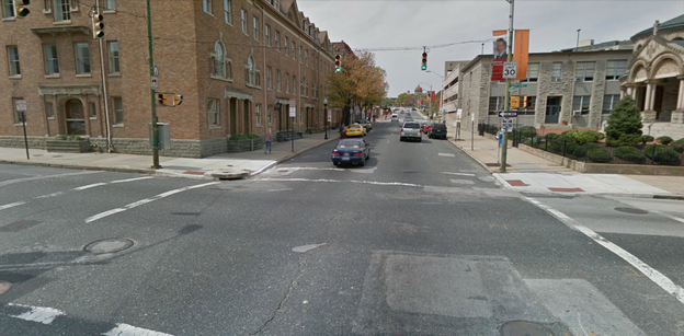
This means that people on foot and on bicycles get a 5-second head start at every intersection, thus increasing their visibility and calming traffic by reducing potentially aggressive maneuvers from people in motor vehicles stopped at red lights. For example, as shown in the image below, a left turn on red is presently allowed from westbound Preston Street onto southbound Maryland Avenue; people in cars trying to make a left turn on red will be looking to their right for southbound car traffic here, which means they are less likely to see people on bicycles traveling northbound on the Maryland Avenue Cycletrack. Banning all turns on red would simply reduce the amount of things that people on foot and on bicycles would need to worry about.

Facing west on Preston Street at Maryland Avenue.

Facing west on Preston Street at Maryland Avenue.

An existing leading pedestrian interval at Pratt and Light Streets.

An existing leading pedestrian interval at Pratt and Light Streets.

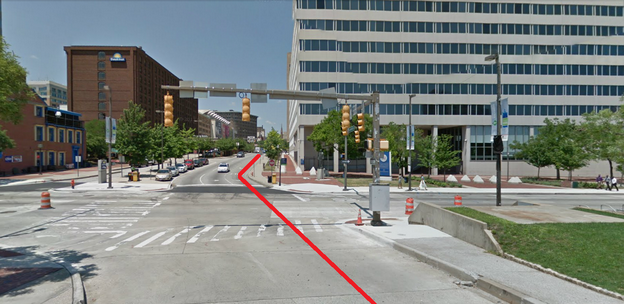
Extend the Maryland Avenue Cycletrack from Hopkins Place across Pratt Street and along the east side of Sharp Street under the Convention Center, and create a high-quality connection across Conway Street to Sharp Street.

This view, looking north from Sharp Street across Pratt Street to Hopkins Place, shows in red the route that an extended Cycletrack should take.

This view, looking north from Sharp Street across Pratt Street to Hopkins Place, shows in red the route that an extended Cycletrack should take.

Install wayfinding signage at major bicycle intersections:

  • Maryland Avenue / Cathedral Street / Liberty Street / Hopkins Place at 27th Street, 24th Street, Jones Falls Trail, Oliver, Biddle, Preston, Madison Street, Centre, Lombard, and Pratt

  • Dolphin Street at Pennsylvania, Druid Hill Ave, McCulloh, Madison Avenue, and Eutaw

  • Preston Street at Maryland, Guilford, Central, Caroline, Broadway, Wolfe, and Washington

  • Biddle Street at Maryland, Guilford, Central, Caroline, Broadway, Wolfe, and Washington

  • Madison Street at Eutaw, Park, Cathedral, Guilford, Fallsway, Central, Caroline, Broadway, Wolfe, and Washington

  • Centre Street at Eutaw, Park, Cathedral, Guilford, and Fallsway

  • Monument Street at Central, Caroline, Broadway, Wolfe, and Washington

  • Guilford Avenue / South Street at Pratt, Lombard, Centre, Madison Street, Chase, Biddle, Preston, and Mount Royal

Existing bicycle wayfinding signage on Guilford Avenue (photo courtesy of BCDOT).

Existing bicycle wayfinding signage on Guilford Avenue (photo courtesy of BCDOT).

Increase the door zone buffer to three (3) feet along the entire Maryland Avenue Cycletrack corridor. Three feet is the NACTO Design Guide standard for door zone buffer width, and the Cycletrack plans currently only call for two feet. The door zone buffer delineates the space where people should not ride because of opening car doors.

A 3-foot buffer on the 15th Street Cycletrack in Washington, D.C., cited by BCDOT as a model for the Maryland Avenue Cycletrack.

A 3-foot buffer on the 15th Street Cycletrack in Washington, D.C., cited by BCDOT as a model for the Maryland Avenue Cycletrack.

Install a reflective bollard at the north side of each block along the Maryland Avenue Cycletrack corridor so that southbound automotive traffic cannot enter the bicycle lane.

Cycletrack in Vancouver with bollard. Photo courtesy of velotraffic.com.

Cycletrack in Vancouver with bollard. Photo courtesy of velotraffic.com.

Install traffic separators on the door zone buffer along the full Maryland Avenue Cycletrack corridor to increase the awareness and feeling of separation and to simulate curb for parallel parking.

Traffic separators on a bicycle lane in Barcelona. Photo courtesy of pedalforward.blogspot.com.

Traffic separators on a bicycle lane in Barcelona. Photo courtesy of pedalforward.blogspot.com.

How To Report Vehicles Parked In Bicycle Paths and Lanes In Baltimore

Via iPhone/Android

Step 1: Download the Baltimore 311 application for iPhone or Android

Step 2: Click "New Request."

New Request

Step 3: Select "Parking Complaint" under "Signs, Signals, & Parking."

Parking Complaint

Step 4: Add photo (if desired), location, and description of complaint. 

Complaint

Step 5: Under Violation, select "Bike Lane (parked in)," and submit complaint.

Violation Detail

Via Desktop

Step 1: Go to http://csr.baltimorecity.gov/ and click "Create new Service Request." 

Step 2: Select Service Type "Illegal Parking Complaint," click "Go," and type in the location of the violation. 

step 1.png

Step 3: From the "How is the vehicle illegally parked?" drop-down menu, pick "Bike Lane (parked in) and follow the rest of the prompts. 

step 2.png

Doing this accomplishes two things: 1) It directs police to respond ASAP, and illegal parkers might get ticketed, depending on the response time; 2) It creates a data set that we will examine going forward to determine who are the biggest violators, where the most violators are, etc.

Happy reporting!